FOREFLIGHT MOBILE
GLOBAL HAZARD AWARENESS
No sneak peaks. ForeFlight Mobile features a variety of hazard avoidance technologies that use Jeppesen’s global high-resolution terrain and obstacle data to provide pilots with better situational awareness and safety, anywhere they fly.

Hazard Advisor
From preflight altitude planning to inflight terrain awareness, Hazard Advisor highlights potentially hazardous terrain and obstacles in prominent red and yellow colors to indicate where terrain comes close to your planned or actual altitude. Terrain and obstacles (“hazards”) within 100′ are colored red, and hazards within 1,000′ of your aircraft’s altitude are colored yellow. Obstacles are dynamically added to the screen as they become threats.
Watch the video
Profile View with Airspace, Weather, Terrain, & Obstacles
Profile View takes our Hazard Advisor feature into vertical mode and gives you a side view of airspace, weather, terrain, and obstacles along your route.
On the Ground
Use Profile view to easily determine the highest point along your route, how much clearance you have over that highest point, and if your planned altitude intersects with any weather, terrain, or obstacles.
In the Air
Profile view scrolls along as you fly and continuously updates your height AGL. Pack for your trip to view weather and airspace in Profile view while in the sky.

Watch the Video
Per-Leg Altitude in Profile
Easily plan enroute altitude changes around terrain, weather, or airspace and visualize them in Profile View, with the option to start or end a climb or descent at a specified waypoint. To plan an altitude change at a specific waypoint, tap the waypoint’s bubble in the FPL Route Editor and tap Set Altitude/Speed/Time, or tap the waypoint’s label in Profile View.
Available with Essential subscriptions and above.
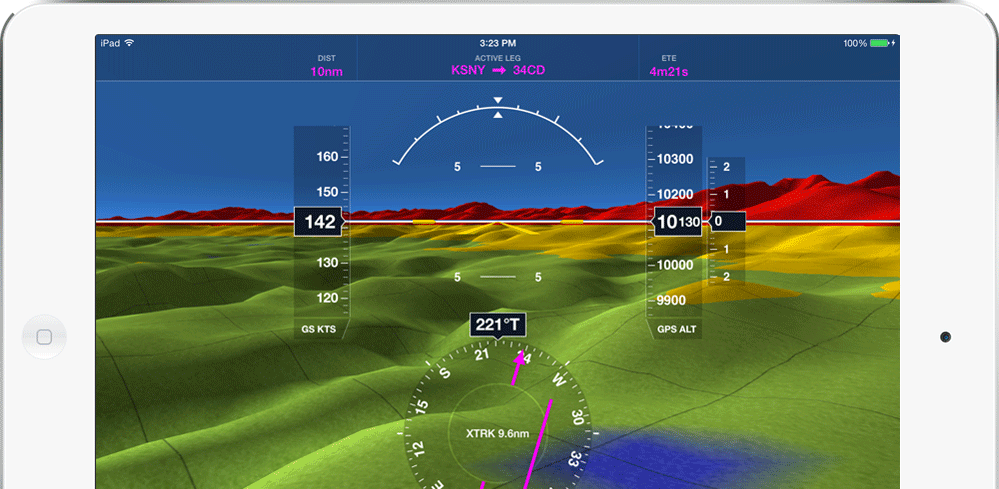
Global Synthetic Vision
Fly with more confidence in all conditions and terrain with this visually stunning and high-performance hazard awareness capability for iPad. ForeFlight’s Synthetic Vision uses Jeppesen’s terrain data sets, designed for use in certified panel-mounted avionics.
Automated Terrain & Obstacle Hazard Alerts Enhance Safety
Our inflight safety tech now detects and warns of threatening obstacles and terrain using visual and audio alerts that display app-wide. The system detects proximity to airports and the approach path and automatically adjusts the scan to reduce nuisance alerts. Turn on Hazard Alerts in More > Settings > Alerts. Available for customers on Essential or higher.
WATCH THE VIDEO: HAZARD ALERTS
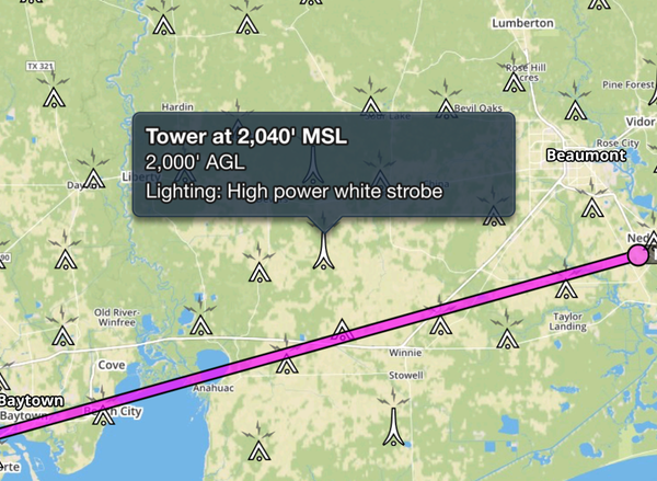
Obstacles
Turning on the obstacles layer on the map view allows you to tap on any obstacle on a chart to get detailed information on lighting, type, and MSL and AGL height.
A High Quality, Void-Filled Terrain Database
Terrain databases are not made equal. The source of the terrain data is a very important consideration. Free data sets used by some applications have holes – or “voids” – that miss important features like mountain peaks. These holes exist for a variety of technical reasons, but need correcting.
ForeFlight’s terrain database, however, is “void filled”. If the terrain database you fly with is not void filled, you are not getting the whole picture.

Plan & Fly with More Confidence
Flying with ForeFlight’s advanced features like Hazard Advisor, Terrain Profile View, and 3D Synthetic Vision gives you a clear picture of terrain and obstacle hazards anywhere in the world. These features and more are included in the Essential and Premium plans.