ForeFlight for European Pilots
ForeFlight is the all-in-one flight app that gives European VFR and IFR pilots everything they need for more efficient flight planning and safer flying. Download ForeFlight from the Apple App Store for a free 30-day trial.


What is ForeFlight?
ForeFlight, available on iPad and iPhone, goes beyond traditional chart viewers and route planners, serving as an integrated flight app that empowers pilots at every stage. From comprehensive flight planning and real-time weather updates to advanced charting and inflight support, ForeFlight offers a suite of intuitive features to enhance your flying experience.
Charts and Data
Flight Planning
Situational Awareness
Weather
Who is ForeFlight for?
From glider pilots to business jet operators, ForeFlight helps pilots of all types and experience levels plan and
fly more safely and efficiently:

VFR Pilots
- Decluttered Map: Customize your map to hide unnecessary elements for a simpler view.
- Inflight Airspace Alerts: Receive alerts and frequencies to fly confidently in busy airspace.
- Easy App Setup: Install and start planning your first flight in minutes with an intuitive interface.

IFR Pilots
- Built-in IFR maps and Procedure Charts: Access Eurocontrol-sourced IFR enroute charts, procedure charts, and AIP documents.
- Procedure Charts on Map: Overlay georeferenced procedure charts and airport diagrams directly on the map alongside other map elements for a critical situational awareness boost.

Business Pilots
- Collaborative Product Suite: ForeFlight’s products for Business operators connect flight planners and pilots for a seamless flight planning experience, simplifying and optimizing the entire process.
- Runway Analysis and W&B: Streamlines operations and reduces risk by automating manual data entry with world-class performance data.
GET STARTED NOW
Charts & Data
ForeFlight equips European pilots with comprehensive aeronautical map data, seamlessly integrating essential information for both VFR and IFR flights, and offers the flexibility of incorporating included IFR charts or optional VFR charts based on individual preferences.

- Customizable Aeronautical Map
Data-driven map based on high quality VFR and IFR aeronautical data from Jeppesen and others, with extensive customization options to show only the information you want to see. - Built-In IFR Maps, Procedure Charts, & Documents
In addition to its effective support for both VFR and IFR planning, the Aeronautical Map incorporates IFR high and low enroute charts, procedure charts, and AIP documents, all included with every subscription. - Optional Add-On Charts
Supplement built-in maps and charts with optional VFR aeronautical and procedure charts from DFS, Rogers Data, Air Million, and others, plus Jeppesen VFR and IFR procedure charts.
Flight Planning
ForeFlight streamlines flight planning by providing a comprehensive suite of tools and information within a single app, facilitating effortless VFR or IFR flight planning and filing.

Route Planning
Effortlessly plan VFR or IFR routes with ForeFlight's intuitive touch-planning or automatic Recommended Route generation, providing instant performance calculations for ETE and fuel burn estimates.

Flight Plan Filing
File your VFR or IFR flights just as easily as you planned them with ForeFlight’s direct connection to the global filing network and automatic EUROCONTROL route validation.

Airport & NOTAM Info
All airport information, including frequencies, runway details, and real-time NOTAMs, are easily accessible on ForeFlight, and you can visualize enroute NOTAMs on the map to plan your route accordingly.
Situational Awareness & Connectivity
ForeFlight's inflight features elevate pilots' situational awareness throughout the entire journey, from taxiway to touchdown, enhancing inflight workflows for a more focused and safer experience in crowded skies.
VIEW ALL DEVICE INTEGRATIONS VIEW BUYING GUIDE
Superior Hazard Awareness
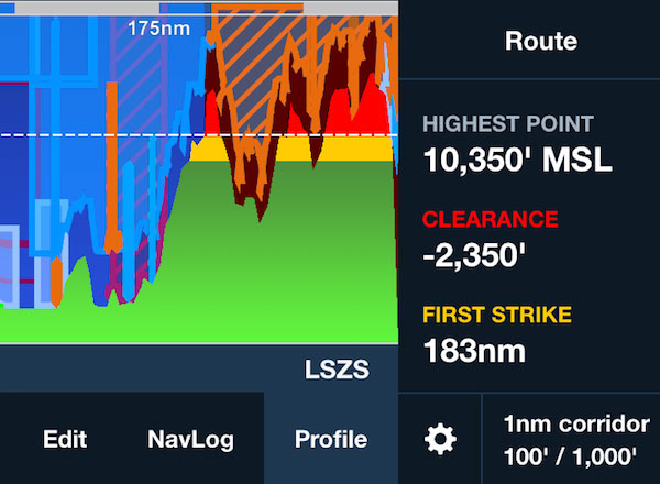
Profile View, Hazard Advisor, and Synthetic Vision work together to highlight nearby terrain and obstacles, ensuring no peak or tower goes unnoticed.

Helpful Map Overlays
Enhance your display with informative map overlays like glide range ring, distance rings, customizable track vector, and a breadcrumb trail of your flight path.

Timely & Informative Alerts
Like a helpful copilot, ForeFlight provides timely information and safety alerts, including customizable airspace alerts, runway encroachment alerts, inflight traffic alerts, and more.

Broad Cockpit Connectivity
ForeFlight integrates with a wide range of installed and portable devices for enhanced safety and situational awareness, including two-way flight plan transfer, ADS-B and FLARM traffic, AHRS pitch and bank, GPS position and more.
Weather
ForeFlight helps you make more informed go/no-go decisions by offering a wide range of current and forecast weather features.

Dynamic Weather Layers
ForeFlight displays radar, satellite, icing/turbulence/cloud coverage forecasts, GAFOR, and METAR-derived conditions directly on the map for comprehensive weather visualization.

Weather Forecast
Access METARs, TAFs, and a versatile daily/hourly general forecast applicable anywhere.

Preflight Briefing
Generate a PDF briefing that combines graphical forecast charts, color-coded METARs/TAFs, and comprehensive NOTAMs for your filed route.
Register For A Webinar
Explore our past webinars and stay tuned for upcoming sessions by watching and registering.