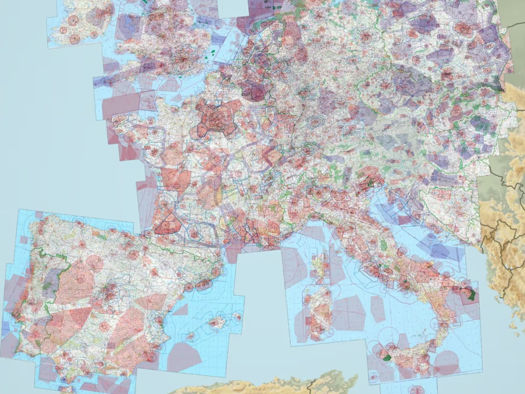
Expanded Coverage for Czech Republic, Slovakia, Hungary, Poland, and Greenland
- All European subscribers can now download AIPs for the Czech Republic, Slovakia, Hungary, Poland, and Greenland, which include IFR procedure charts and airport diagrams for all countries; VFR procedure charts for the Czech Republic, Hungary, and Poland; IFR High and Low enroute charts for the Czech Republic, Hungary, Poland, and Slovakia; and documents for all countries. Jeppesen’s IFR and VFR aeronautical data is also included for all countries except Greenland (IFR data only).
- A wide range of new optional add-ons from DFS and Rogers Data are also available to enhance your visual flying.
- DFS VFR 500 Charts covering the Czech Republic, Hungary, and Poland, along with an “All Europe” VFR/Visual 500 Chart combo that provides access to all DFS VFR charts available through ForeFlight.
- Rogers Data VFR 500k charts covering Italy, Great Britain and Ireland, Spain and Portugal, France and Corsica, VFR 200k charts covering Austria and Slovenia, and Rogers Data VFR 500k Charts Combo covering most of central, southern, and eastern Europe.
- Visit foreflight.com/europe/data to learn more about what data is available for Europe and compare coverage for different countries.
Track Log Review
- A new graphical Track Log view provides detailed metrics for a better postflight debrief.
- The new Track Log Graph shows changes in a flight’s altitude and speed based on GPS data, as well as pitch and bank if connected to an AHRS-capable device like Sentry, allowing you to view multiple data streams at once for better visualization and assessment.
- Replay your flight in fast-forward mode or manually scrub through the timeline.
- Spread and pinch to resize the view and swipe left or right to get a better view of maneuvers or other details.
- Access additional Track Log information by tapping the Info button in the top right of the Track Log Review page.
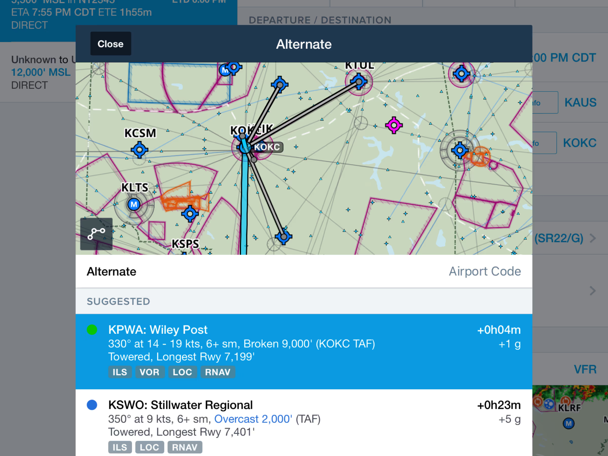
Alternate Advisor
- Quickly find suitable alternate airports near your destination.
- Alternates are suggested based on ForeFlight’s machine learning algorithm which analyzes other similar filed flight plans, as well as time and fuel requirements, forecast weather conditions, available approach procedures, and more.
- Access Alternate Advisor by tapping in the Alternate field in the Flights view.
Select Runway on Maps
- Tap on the departure or destination airport bubble in the Maps view Route Editor to select a runway.
- Runway “Best Wind” labels indicate which runways have a headwind.
- When selected, the destination runway is highlighted on the map with a blue line and chevrons, making it easier to quickly identify the correct runway before landing.
- Selecting a departure runway adds white chevrons extending out from the centerline.
- Selecting runways in the Route Editor automatically selects those runways in the Takeoff & Landing Performance views after you send the route to the Flights view.
Organized Track Systems (OTS) Filtering
- Filter oceanic tracks on ForeFlight’s Maps view by direction.
- Under Map Settings > Airways, select Easterly tracks, Westerly tracks, or all tracks.
- Organized Track Systems are included in ForeFlight Premium plans.
SkyEcho 2 FLARM Support
- ForeFlight can now decode and display FLARM traffic data from uAvionix’s SkyEcho 2 portable GPS and ADS-B transceiver. FLARM traffic appears on ForeFlight’s map just like ADS-B traffic, with basic information about each traffic target.
- ForeFlight requires a FLARM Decoding License to display FLARM traffic when connected to a SkyEcho 2. You can purchase a FLARM Decoding License on ForeFlight’s website.


.avif)