Mountain flying isn’t just a scenic cruise
There’s truly something magical about soaring through a valley surrounded by jagged peaks, sunlight bouncing off the ridgelines as cool air rushes past your wingtips or rotorblades. But behind all of that beauty lie plenty of flying challenges. Mountain flying introduces unique variables like vertical drafts, turbulence, shifting density altitude, narrow passes, strong winds aloft, and a powerful phenomenon called mountain waves.
What are mountain waves? Let’s start with the science behind it.
When wind flows nearly perpendicular to a mountain range at moderate or high speeds and the atmosphere is stable, waves form that can stretch thousands of feet above and beyond the ridge. These invisible waves bring rapid climbs and sudden descents that can surprise even experienced pilots. As a pilot, understanding when and where they appear is one of the smartest things you can do before venturing into the mountains in your aircraft.
Planning altitude and terrain with confidence
I’d say one of the hardest parts of mountain flying is deciding on an altitude that keeps you safely above terrain, but also leaves room to adapt to changing conditions. In military aviation we call this an escape route. While you’re in the air, ForeFlight’s Profile View and Hazard Advisor are great tools to lean on in these situations. They can help take much of the guesswork out of making that decision.
Profile View shows a side-on cross section of your route, displaying the terrain beneath you and highlighting the high points along the way. You can scroll through the entire route before takeoff and instantly see where a climb is required or where a lower altitude might work safely.
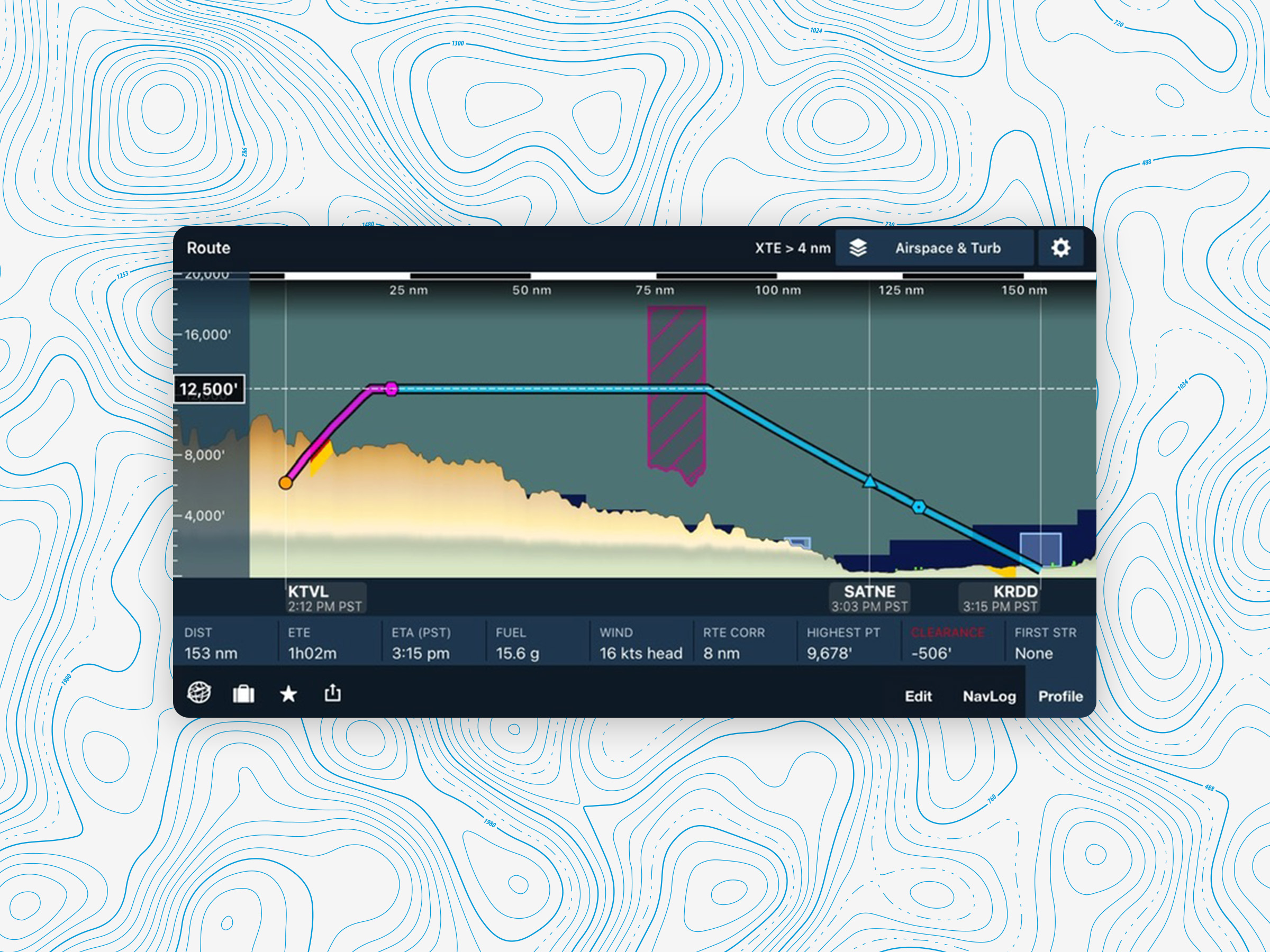
If that’s not already the greatest tool, Hazard Advisor adds even more safety awareness. It color-codes the terrain and obstacles along your path, showing red where you’re within 100 feet of terrain and yellow where you’re within 1,000 feet. In mountain flying, where ridges can appear quickly, that awareness is essential.
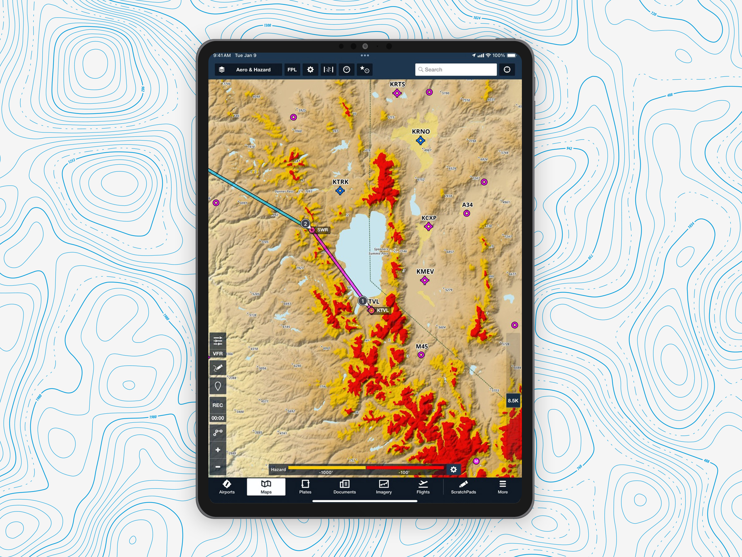
Other favorite features for mountain flying are the Basemap options in the Map Layer selector. The High Resolution Basemap marks individual peaks and named mountain passes along with their elevations, making it easier to find the lowest and safest crossings. For even more detail, the Aerial Map layer provides high-resolution satellite imagery that makes it easy to identify landmarks and vegetation. I like zooming in to get a clear, detailed view of the terrain so I can plan my route with total confidence.

Spotting the wave before it hits
I hate to say it, but mountain waves will often hide in plain sight. You can take off under clear blue skies and still encounter severe turbulence just a few miles downwind of a ridge. The warning signs are pretty subtle: stable air, increasing wind speeds with altitude, and airflow moving nearly perpendicular to the terrain.
Sometimes you may see lenticular clouds stacked like pancakes, but often you don’t. If I see lenticular clouds, my meteorologist brain activates and I immediately know the wind profile is supporting mountain waves and potential aviation hazards.
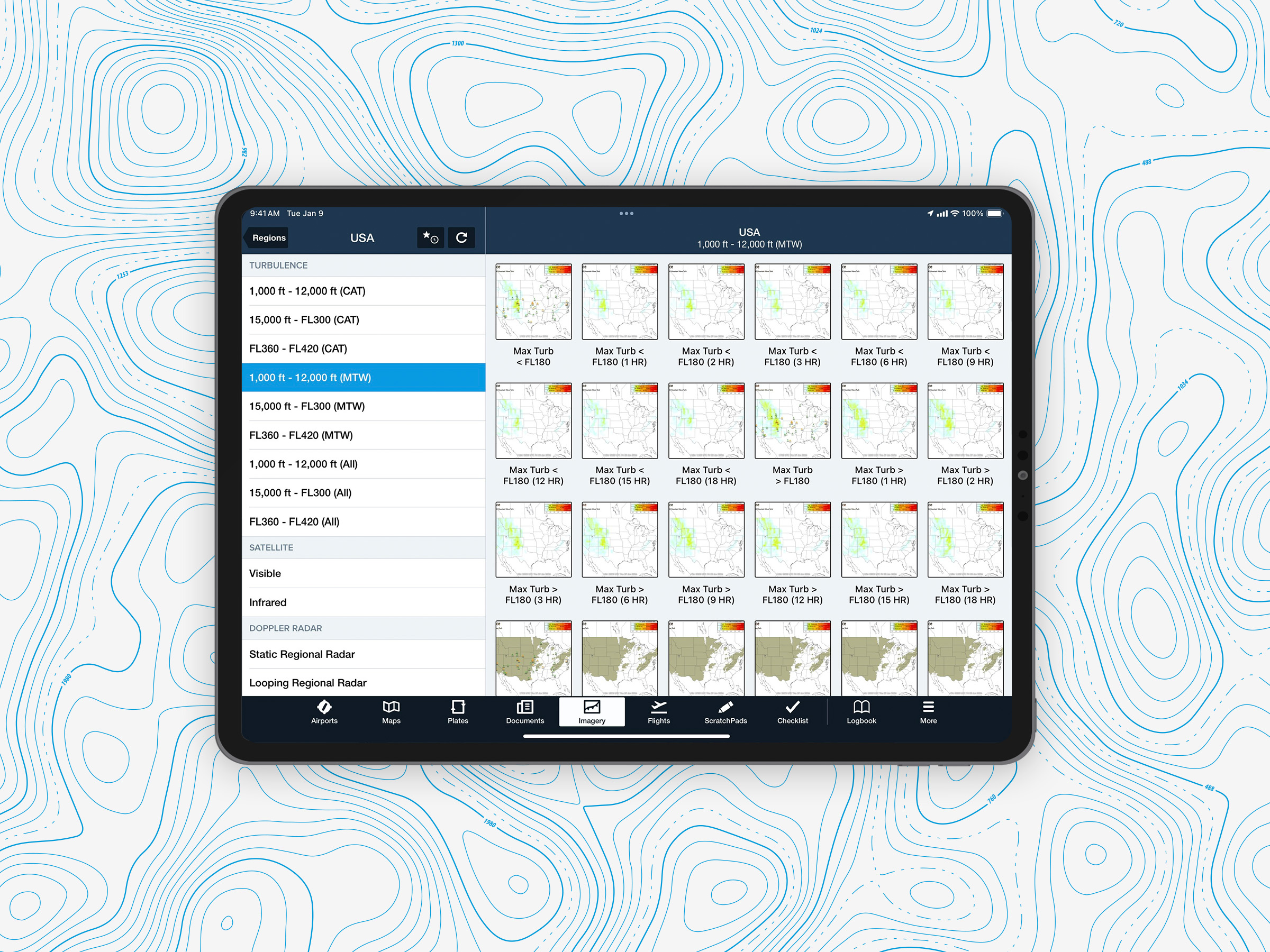
For those times when you’re flight planning at home and can’t yet see the actual conditions off in the distance, ForeFlight can help you anticipate potential wave activity long before takeoff. The turbulence forecast layers in the Map Layers view display predicted turbulence intensity, including mountain wave effects. You can also see color-coded risk zones for mountain wave turbulence at different altitudes by viewing MTW reports under the Turbulence section of the Imagery view.
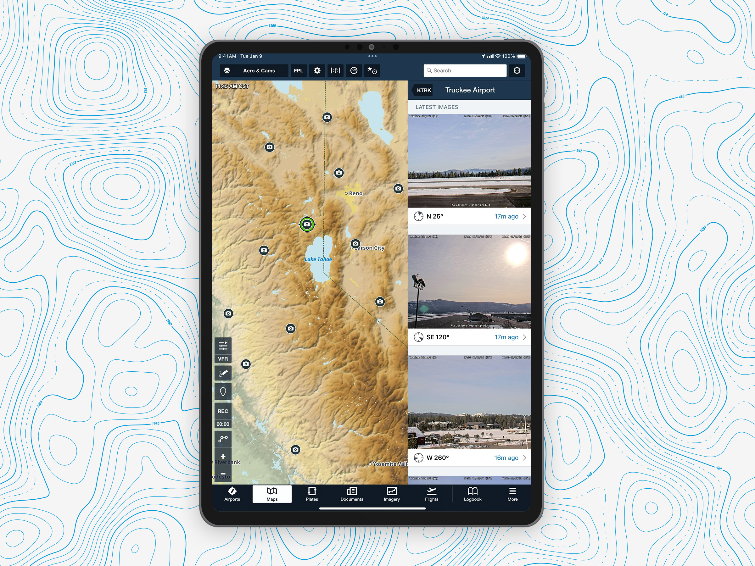
In many mountainous areas, you can also reference real-time images of actual conditions right in the app by enabling the Cameras layer. Tap on any of the 500+ FAA WeatherCams to see timestamped photos, and even compare those to a Clear Day reference photo. This way, you can get visuals for more context around a weather briefing and make better flight planning decisions.
Checking out all of this information while planning gives you options. Maybe you just need to adjust your departure time to avoid the strongest winds, change your altitude to fly above or below the wave, or reroute entirely. Instead of flying into surprises, you’re able to make informed and confident decisions before you ever leave the ground.
The adventure factor: Turning challenge into fun
Mountain flying is one of aviation’s greatest adventures. It’s about skill, preparation, and pure wonder, and it attracts pilots of all levels, from students to seasoned pros. With the right preparation, you can focus on the flight and enjoy the breathtaking views instead of worrying about the unknowns.
The more you experience mountain flying, the more curious you’ll become. You’ll start exploring questions like which pass offers the smoothest ride, how the wind pattern changes by altitude, or where the lenticular clouds are forming. Each flight becomes both an adventure and a lesson in nature’s invisible forces.
Respect the mountains and use the tools
Friendly reminder from a meteorologist: mountain waves and high-country flying demand respect. The terrain, wind, and atmosphere work together in complex ways that challenge every pilot. But so many of the tools we have through ForeFlight make it easier than ever to understand and manage those challenges.
ForeFlight gives you a complete mountain flying toolkit: terrain awareness, turbulence forecasting, altitude planning, and detailed high-resolution maps. If it’s your first time planning a weekend trip through the Appalachian or navigating the Rockies on a cross-country adventure, ForeFlight helps you see the big picture while staying aware of the details.
Always approach the mountains with preparation, respect, and curiosity. Let ForeFlight be your guide as you explore some of the most breathtaking and rewarding flying on Earth. With knowledge and these tools we went over, every flight will become an unforgettable story written in the sky.